


Faja de las Flores

One of the most spectacular hikes in the Pyrenees

Hike high above the Ordesa Valley along a breathtaking trail carved into the mountainside

Faja de las Flores offers a unique perspective on Ordesa from high above. A classic Pyrenean hike, it’s one of the most iconic routes in Ordesa y Monte Perdido National Park.

What makes this hike so special is the feeling of being high above the valley, with panoramic views from 2,400 meters (7,875 ft). The scenery changes as you ascent, starting in the forest and across alpine meadows before reaching the highlight of the route: a narrow ledge, known as the faja, that winds its way along the mountainside.
The route also includes optional sections of iron rungs (clavijas) at Salarons on the way up and Cotatuero on the way down, adding an extra dose of adventure and a technical challenge to this already spectacular hike.

THE QUEEN OF THE FAJAS WITH GUÍAS DEL PIRINEO

HIGH
8 H
FROM 90€

BEST TIME TO GO

JUNE TO OCTOBER

RATIO

6 PEOPLE PER GUIDE

Previous experience

Technical difficulty

Fitness level

Scenery - beauty

Emotion - adrenaline
Commitment - exposure

From the valley floor, the Faja de las Flores looks like little more than a crack in the enormous cliff face. But this natural ledge is around 3 km long and up to 4 meters wide. It was formed as the softer layers of Marboré sandstone eroded faster than the harder rock, creating these impressive ledges along the mountainside.

Despite its beautiful name – literally ‘flowered ledge’ – the Faja de las Flores is not a gentle stroll through a field of flowers. It’s a demanding hike with over 1,000 metres of elevation gain and some technical sections that aren’t suitable for beginners. The name probably comes from the edelweiss flowers that grow along the route, particularly around Cotatuero.

The hike starts at the parking of Pradera de Ordesa. From here, we head towards Casa de Oliván, an old hunters’ refuge, and follow the trail towards the Carriata Cirque, Faja Racón and Tozal del Mallo. The path climbs steeply through a beech and fir forest before opening out onto mountain meadows. As the trees thin out, Tozal del Mallo comes into view,.

From here, we can either climb via the Salarons iron rungs (clavijas) or take the Fajeta path to avoid them. Both routes have some steep and narrow sections, and our guides will help you navigate them safely.

Once we’ve made it past this section, we continue up a steep grassy slope until we reach the start of the Faja de las Flores. The trail along the ledge is easy to follow, and the views are out of this world. We’ll look out over the Cotatuero Cirque, with the peaks of Marboré, Cilindro, Monte Perdido and Añisclo in the distance. There’s plenty to take in! Most of the ledge is nice and wide, but it can still be quite impressive.

Towards the end, the ledge gets narrower and the path steeper. We can now spot the Brecha de Rolando, Gabietos, Taillón and the Tres Sorores, with the Ordesa Valley stretching out far below us. Your guide will point it out. And… have you already spotted some marmots or chamois?

The way down starts with a rocky descent. Eventually, we reach the entrance to the Cotatuero Cirque and the most technical part of the hike: the Cotatuero iron rungs (clavijas). This is the steepest and most rugged section, but the views are just as impressive, with the Cotatuero Waterfall right next o us.
The crossing is equipped with 33 iron rungs fixed into the rock, along with a safety cable. They help us cross 12-meter-long rock passage. Our guides are certified to take you through this section using the necessary equipment. If you’re curious about the history of these iron rungs, you can read more at the end of this page.

From here, we head downhill through the forest. We eventually join the main trail which takes us back to Pradera de Ordesa.

TO KNOW MORE...

The story of the Cotatuero iron rungs and Celia, the last Bucardo

THE LAST PYRENEAN IBEX

We don’t know much about the Salarons iron rungs, other than that they were installed in 1921 to make it easier to access the Salarons Cirque. The story behind the Cotatuero iron rungs, on the other hand, is much better documented.

The Cotatuero iron rungs were installed in 1881, when the Ordesa Valley was still home to the last Pyrenean ibex, also known as the bucardo. These rare animals attracted hunters from far away.
Edward Buxton, an Englishman living in Pau, France, was the one who pushed for the iron rungs to be installed. He preferred this route to reach Gavarnie via the Brecha de Rolando (Roland’s Gap). He hired a blacksmith from Torla to install the 33 iron rungs.
The blacksmith did the work himself, with help from his neighbour, a trout fisherman from the same village. The job cost 250 pesetas, a small amount compared with what Buxton spent on his hunting trips.
Buxton travelled from Pau with 13 porters, two French guides and a large Spanish team to help him hunt. He also paid the local councillors in Torla 350 francs a year for permission to hunt in the Ordesa Valley.

However, Buxton never got to use the iron rungs himself. He had to return to England because his son was seriously ill.
The route was first completed by Tissandier and his guide, Pujo, on 14 July 1892. The Cadier brothers crossed it in 1903, followed by Lucien Briet in 1909. Briet described the iron rungs as “a solid, unchanging ladder, fit for parrots…”. He wasn’t the only one who disliked them. Henry Russell also strongly criticised the installation, saying it had damaged the mountain.

Was it really worth it? Building a route at the entrance to the Cotatuero Cirque, facing the cold and the risk of avalanches, and travelling so far… all just to hunt the bucardo?

Today, the bucardo is extinct, but for a long time, this Pyrenean ibex went largely unnoticed.

It wasn’t until 1837 that Heinrich Rudolf Schinz, a professor at the University of Zurich, officially identified the bucardo as a species distinct from the Alpine ibex. The two species differed mainly in their horns, beards, and the colouring of their bellies and backs.
Interestingly, Schinz had never visited the Pyrenees. His research was based on a letter he received in 1835 from Friedrich Brunch, a German notary who collected birds and wild animals.
Schinz had never seen a living bucardo, but he introduced the species to scientists across Europe. This sparked growing interest in the rare mountain goat, and in hunting it.

The bucardo population was already small, and growing interest in hunting the newly recognised species made things worse. Records show that 77 animals were killed, although the real number was probably much higher. The species was heading towards extinction.
Hunting the bucardo was banned in 1913, but by then, too few animals remained for the population to recover. A plan to save the species was finally approved in 1993, when only ten animals were left. Just three years later, that number had fallen to four.

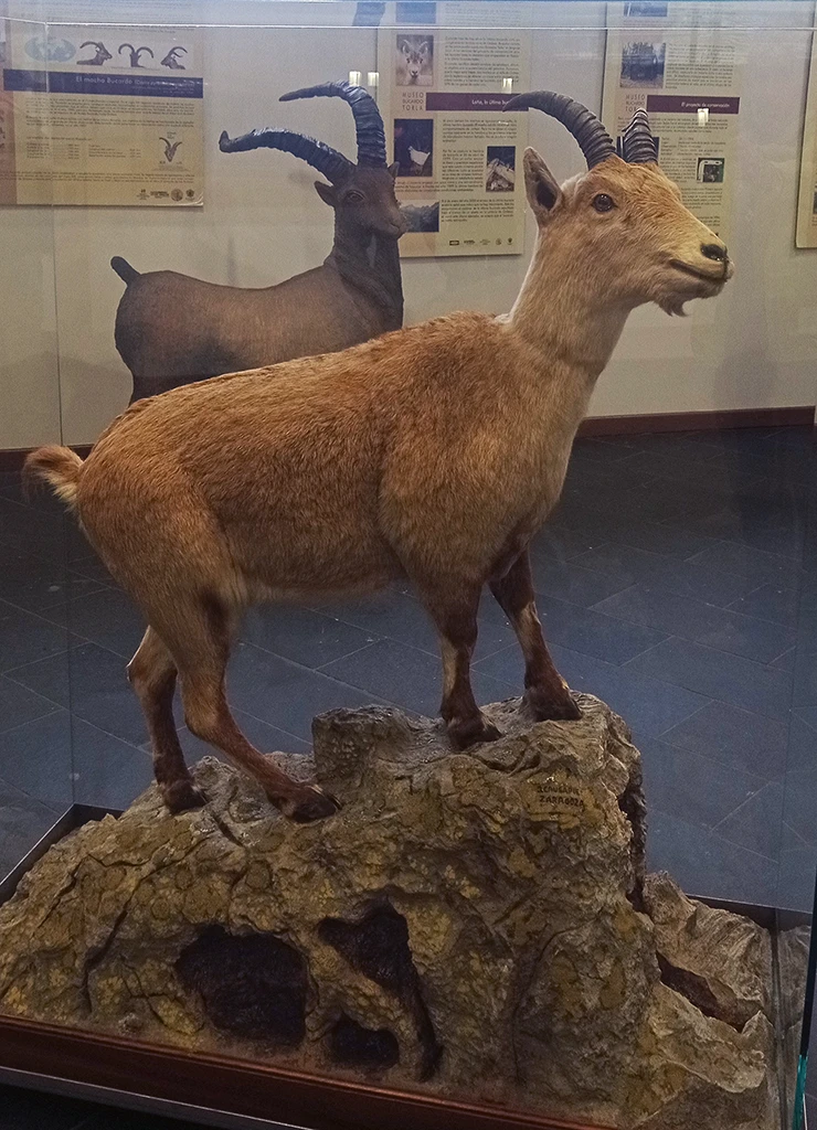
The last bucardo was a female named Celia, also known as Laña. She was 13 years old and weighed 53 kg. On 6 January 2000, she was killed by a falling fir tree during an avalanche in the Faja de Pelay.
Scientists preserved her genetic material in the hope of bringing the species back through cloning. They made several attempts to create bucardo embryos using in vitro fertilisation, but none of the pregnancies succeeded.
Another attempt may be possible in the future, but there is one major problem: genetic material was collected from only one female.

Celia’s body was taken to the Faculty of Veterinary Medicine in Zaragoza, where a team of ten people carefully documented her features. Since late 2012, she has been on display at the visitor centre in Torla.

Edward Buxton may have helped speed up the bucardo’s extinction by having the iron rungs at Cotatuero installed to make the route easier to cross. He killed only four bucardos himself, but the new route may have made it easier for other hunters to reach them.
At the same time, Buxton cared about the environment. He repeatedly criticised the damage caused by human activity in the Ordesa Valley, including the cutting down of beech trees.
It raises an interesting question: if Buxton had known that the route might contribute to the bucardo’s extinction, would he still have had the iron rungs installed? Or would he have left the passage untouched, keeping it out of reach of hunters looking for a prized trophy?

Sources: Desnivel; Heraldo; El Periódico de Aragón; Kees Woutersen (2012), El Buscador de los Pirineos, Kees Woutersen Publications.

PRICES

From 90€/person

Prices per person for a group of 4. Get in touch for other group sizes and options.

INCLUDED

– Qualified mountain guide
– Public liability and accident insurance
– Harness, helmet and via ferrata-set

NOT INCLUDED

– Transport
– Shuttle bus from Torla to the parking of Ordesa (only in high season)

– Picnic

REQUIREMENTS

A reasonable level of fitness, with no injuries, conditions or illnesses that could prevent you from walking comfortably on tracks and trails with varying gradients.

MATERIAL NECESARIO

Hiking boots, a windproof and waterproof jacket, sunglasses, sunscreen, a 20-liter backpack, plenty of water and picnic. In autumn, bring suitable warm layers, gloves and a warm hat.

Join us and discover the best hiking trails in the Pyrenees!

COOPERATIVA GUIAS DEL PIRINEO
Privacy Overview

This website uses cookies so that we can provide you with the best user experience possible. Cookie information is stored in your browser and performs functions such as recognising you when you return to our website and helping our team to understand which sections of the website you find most interesting and useful.